


089KE - KNOLLWOOD ELEM Voting District, DeKalb County, Georgia
About
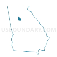
Outline

Summary
| Unique Area Identifier | 561120 |
| Name | 089KE - KNOLLWOOD ELEM Voting District |
| County | DeKalb County |
| State | Georgia |
| Area (square miles) | 0.87 |
| Land Area (square miles) | 0.86 |
| Water Area (square miles) | 0.00 |
| % of Land Area | 99.91 |
| % of Water Area | 0.09 |
| Latitude of the Internal Point | 33.74495870 |
| Longtitude of the Internal Point | -84.26574760 |
Maps


Graphs
Select a template below for downloading or customizing gragh for 089KE - KNOLLWOOD ELEM Voting District, DeKalb County, Georgia


Neighbors
Neighoring Voting District (by Name) Neighboring Voting District on the Map
- 089AF - HOOPER ALEXANDER Voting District, DeKalb County, GA
- 089CA - COLUMBIA DRIVE Voting District, DeKalb County, GA
- 089CQ - CANDLER Voting District, DeKalb County, GA
- 089MO - MIDWAY ELEM Voting District, DeKalb County, GA
- 089PA - PEACHCREST ELEM Voting District, DeKalb County, GA
- 089WA - WADSWORTH ELEM Voting District, DeKalb County, GA
Top 10 Neighboring County Subdivision (by Population) Neighboring County Subdivision on the Map
Top 10 Neighboring Place (by Population) Neighboring Place on the Map
Top 10 Neighboring Unified School District (by Population) Neighboring Unified School District on the Map
Top 10 Neighboring State Legislative District Lower Chamber (by Population) Neighboring State Legislative District Lower Chamber on the Map
Top 10 Neighboring State Legislative District Upper Chamber (by Population) Neighboring State Legislative District Upper Chamber on the Map
Top 10 Neighboring 111th Congressional District (by Population) Neighboring 111th Congressional District on the Map
Top 10 Neighboring Census Tract (by Population) Neighboring Census Tract on the Map
- Census Tract 235.06, DeKalb County, GA (5,910)
- Census Tract 231.01, DeKalb County, GA (4,484)
- Census Tract 231.07, DeKalb County, GA (4,452)
- Census Tract 229, DeKalb County, GA (3,552)
- Census Tract 235.01, DeKalb County, GA (3,550)